Geolocate

Casper topographic map

Click on the map to display elevation.

About this map

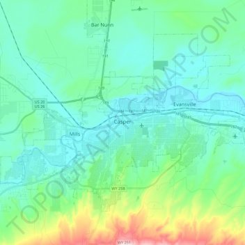
Name: Casper topographic map, elevation, terrain.

Location: Casper, Natrona County, Wyoming, United States (42.79129 -106.43497 42.90753 -106.21571)

Average elevation: 5,364 ft

Minimum elevation: 5,072 ft

Maximum elevation: 6,594 ft

Natrona County trails, hiking, mountain biking, running and outdoor activities

Other topographic maps

Click on a map to view its topography, its elevation and its terrain.

Casper

United States > Wyoming > Natrona County > Casper

Average elevation: 5,666 ft

Red Butte

United States > Wyoming > Natrona County

Average elevation: 5,256 ft

Mills

United States > Wyoming > Natrona County

Average elevation: 5,187 ft

Gear up for your next adventure:

🛰️Handheld GPS Units - Professional satellite navigators for precise backcountry mapping
🌄Hiking Binoculars - Compact binoculars for scenic views and trail spotting
🏥Hiking First Aid Kits - Comprehensive medical kits for remote trail injuries
🛠️Outdoor Gear Repair Kit - Essential tools to fix gear on the trail
🛏️Cold Weather Sleeping Bag - Warm sleeping bag for cold conditions

As an Amazon Associate, this site earns from qualifying purchases at no extra cost to you.