
Make a donation
Gear up for your next adventure:
As an Amazon Associate, this site earns from qualifying purchases at no extra cost to you.
Mooiuitsig topographic map
Click on the map to display elevation.
Make a donation
Gear up for your next adventure:
As an Amazon Associate, this site earns from qualifying purchases at no extra cost to you.
About this map
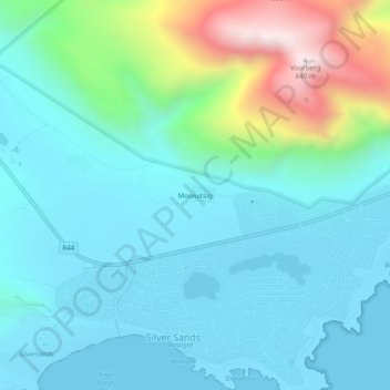
Name: Mooiuitsig topographic map, elevation, terrain.
Average elevation: 568 ft
Minimum elevation: -3 ft
Maximum elevation: 2,782 ft
Make a donation
Gear up for your next adventure:
As an Amazon Associate, this site earns from qualifying purchases at no extra cost to you.
Other topographic maps
Click on a map to view its topography, its elevation and its terrain.
Pearly Beach
South Africa > Western Cape > Overberg District Municipality > Overstrand Local Municipality
Average elevation: 36 ft
Kleinmond
South Africa > Western Cape > Overberg District Municipality > Overstrand Local Municipality
Average elevation: 390 ft
Baardskeerdersbos
South Africa > Western Cape > Overberg District Municipality > Overstrand Local Municipality
Average elevation: 394 ft
Onrus River
South Africa > Western Cape > Overberg District Municipality > Overstrand Local Municipality
Average elevation: 761 ft
Make a donation
Gear up for your next adventure:
As an Amazon Associate, this site earns from qualifying purchases at no extra cost to you.
Walker Bay
South Africa > Western Cape > Overberg District Municipality > Overstrand Local Municipality
Average elevation: 66 ft
Dyer Island
South Africa > Western Cape > Overberg District Municipality > Overstrand Local Municipality
Average elevation: 0 ft
Geyser Island
South Africa > Western Cape > Overberg District Municipality > Overstrand Local Municipality
Average elevation: 0 ft
Pearly Beach
South Africa > Western Cape > Overberg District Municipality > Overstrand Local Municipality
Average elevation: 36 ft
Make a donation
Gear up for your next adventure:
As an Amazon Associate, this site earns from qualifying purchases at no extra cost to you.
Walker Bay
South Africa > Western Cape > Overberg District Municipality > Overstrand Local Municipality
Average elevation: 66 ft
Baardskeerdersbos
South Africa > Western Cape > Overberg District Municipality > Overstrand Local Municipality
Average elevation: 394 ft
Onrusrivier
South Africa > Western Cape > Overberg District Municipality > Overstrand Local Municipality
Average elevation: 430 ft