
Make a donation
Gear up for your next adventure:
As an Amazon Associate, this site earns from qualifying purchases at no extra cost to you.
Hall in Tirol topographic map
Click on the map to display elevation.
Make a donation
Gear up for your next adventure:
As an Amazon Associate, this site earns from qualifying purchases at no extra cost to you.
Hall in Tirol
Hall in Tirol is a town in the Innsbruck-Land district of Tyrol, Austria. Located at an altitude of 574 m, about 5 km (3 mi) east of the state's capital Innsbruck in the Inn valley, it has a population of 14,771 (Dec 2023).
Make a donation
Gear up for your next adventure:
As an Amazon Associate, this site earns from qualifying purchases at no extra cost to you.
About this map
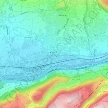
Name: Hall in Tirol topographic map, elevation, terrain.
Location: Hall in Tirol, Bezirk Innsbruck-Land, Tyrol, 6060, Austria (47.27096 11.47248 47.29125 11.52874)
Average elevation: 2,126 ft
Minimum elevation: 1,814 ft
Maximum elevation: 2,986 ft
Make a donation
Gear up for your next adventure:
As an Amazon Associate, this site earns from qualifying purchases at no extra cost to you.
Other topographic maps
Click on a map to view its topography, its elevation and its terrain.
Hoher Burgstall
Austria > Tyrol > Bezirk Innsbruck-Land > Neustift im Stubaital
Average elevation: 7,028 ft
Make a donation
Gear up for your next adventure:
As an Amazon Associate, this site earns from qualifying purchases at no extra cost to you.
Make a donation
Gear up for your next adventure:
As an Amazon Associate, this site earns from qualifying purchases at no extra cost to you.
Elferspitze
Austria > Tyrol > Bezirk Innsbruck-Land > Neustift im Stubaital
Average elevation: 6,490 ft
Make a donation
Gear up for your next adventure:
As an Amazon Associate, this site earns from qualifying purchases at no extra cost to you.
Make a donation
Gear up for your next adventure:
As an Amazon Associate, this site earns from qualifying purchases at no extra cost to you.
Axamer Lizum
Austria > Tyrol > Bezirk Innsbruck-Land > Gemeinde Axams > Axamer Lizum
Average elevation: 6,096 ft
Make a donation
Gear up for your next adventure:
As an Amazon Associate, this site earns from qualifying purchases at no extra cost to you.