
Lucre topographic map
Interactive map
Click on the map to display elevation.
About this map
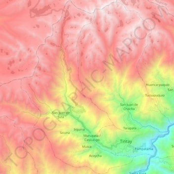
Name: Lucre topographic map, elevation, terrain.
Location: Lucre, Aymaraes, Apurímac, Perú (-13.99341 -73.29619 -13.81506 -73.17750)
Average elevation: 12,582 ft
Minimum elevation: 7,211 ft
Maximum elevation: 16,096 ft
Other topographic maps
Click on a map to view its topography, its elevation and its terrain.
Huillcapata
Huillcapata, Curahuasi, Abancay, Apurímac, Perú
Average elevation: 10,850 ft
Villa El Salvador
Perú > Apurímac > Villa El Salvador
Villa El Salvador, Chincheros, Apurímac, Perú
Average elevation: 11,955 ft
San Miguel
Perú > Apurímac > Andahuaylas > Cconeccpuquio > San Miguel
San Miguel, Cconeccpuquio, Andahuaylas, Provincia de Andahuaylas, Apurímac, 03701, Perú
Average elevation: 10,007 ft
Montevideo
Perú > Apurímac > Montevideo
Montevideo, Chincheros, Apurímac, Perú
Average elevation: 10,659 ft