
Mindoro topographic map
Click on the map to display elevation.
About this map
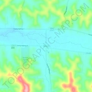
Name: Mindoro topographic map, elevation, terrain.
Average elevation: 876 ft
Minimum elevation: 741 ft
Maximum elevation: 1,257 ft
La Crosse County trails, hiking, mountain biking, running and outdoor activities
Other topographic maps
Click on a map to view its topography, its elevation and its terrain.
Village of West Salem
United States > Wisconsin > La Crosse County > West Salem
Average elevation: 741 ft