
Onalaska topographic map
Interactive map
Click on the map to display elevation.
About this map
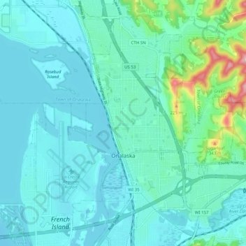
Name: Onalaska topographic map, elevation, terrain.
Location: Onalaska, La Crosse County, Wisconsin, United States (43.86119 -91.24954 43.92386 -91.14970)
Average elevation: 719 ft
Minimum elevation: 623 ft
Maximum elevation: 1,247 ft
Other topographic maps
Click on a map to view its topography, its elevation and its terrain.
La Crosse
United States > Wisconsin > La Crosse County
La Crosse, La Crosse County, Wisconsin, United States
Average elevation: 781 ft
Town of Hamilton
United States > Wisconsin > La Crosse County
Town of Hamilton, La Crosse County, Wisconsin, United States
Average elevation: 899 ft
Medary
United States > Wisconsin > La Crosse County > La Crosse
Medary, La Crosse, La Crosse County, Wisconsin, 54603, United States
Average elevation: 741 ft
City of Onalaska
United States > Wisconsin > La Crosse County > Onalaska
City of Onalaska, Onalaska, La Crosse County, Wisconsin, United States
Average elevation: 781 ft
Bangor
United States > Wisconsin > La Crosse County
Bangor, La Crosse County, Wisconsin, United States
Average elevation: 755 ft
Holmen
United States > Wisconsin > La Crosse County
Holmen, La Crosse County, Wisconsin, United States
Average elevation: 801 ft
Brice Prairie
United States > Wisconsin > La Crosse County
Brice Prairie, La Crosse County, Wisconsin, United States
Average elevation: 659 ft
Midway
United States > Wisconsin > La Crosse County
Midway, Town of Onalaska, La Crosse County, Wisconsin, 54650, United States
Average elevation: 702 ft
Madison Court
United States > Wisconsin > La Crosse County > La Crosse
Madison Court, La Crosse, La Crosse County, Wisconsin, United States
Average elevation: 751 ft
Village of West Salem
United States > Wisconsin > La Crosse County > West Salem
Village of West Salem, West Salem, Town of Hamilton, La Crosse County, Wisconsin, United States
Average elevation: 741 ft
Saint Joseph
United States > Wisconsin > La Crosse County
Saint Joseph, Town of Greenfield, La Crosse County, Wisconsin, United States
Average elevation: 1,165 ft
Mindoro
United States > Wisconsin > La Crosse County
Mindoro, Town of Farmington, La Crosse County, Wisconsin, 54644, United States
Average elevation: 876 ft
Bell Island
United States > Wisconsin > La Crosse County > La Crosse
Bell Island, La Crosse, La Crosse County, Wisconsin, 54650, United States
Average elevation: 948 ft
La Crosse
United States > Wisconsin > La Crosse County > La Crosse
La Crosse, La Crosse County, Wisconsin, 54602, United States
Average elevation: 896 ft
West Salem
United States > Wisconsin > La Crosse County
West Salem, La Crosse County, Wisconsin, 54669, United States
Average elevation: 794 ft