Geolocate

Mühlacker topographic map

Click on the map to display elevation.

About this map

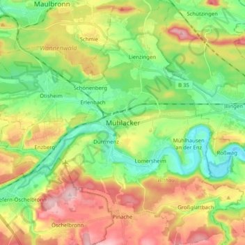
Name: Mühlacker topographic map, elevation, terrain.

Location: Mühlacker, VVG der Stadt Mühlacker, Enzkreis, Baden-Württemberg, 75417, Germany (48.89723 8.77045 49.00025 8.92636)

Average elevation: 942 ft

Minimum elevation: 673 ft

Maximum elevation: 1,332 ft

Other topographic maps

Click on a map to view its topography, its elevation and its terrain.

Bauschlott

Germany > Baden-Württemberg > Enzkreis

Average elevation: 1,014 ft

Göbrichen

Germany > Baden-Württemberg > Enzkreis

Average elevation: 1,070 ft

Schlossbergturm

Germany > Baden-Württemberg > Enzkreis > Sternenfels

Average elevation: 1,050 ft

Holzbachtal

Germany > Baden-Württemberg > Enzkreis > Straubenhardt > Langenalb

Average elevation: 1,473 ft

Enzberg

Germany > Baden-Württemberg > Enzkreis > Mühlacker

Average elevation: 945 ft

Gear up for your next adventure:

🎁Geography Themed Gifts - Unique gift ideas for map lovers and geography enthusiasts
🧯Portable Fire Pit - Compact fire pit for camping spots
📚Navigation Handbooks - Master the art of reading topographic maps and using a compass
🪓Survival Multi‑Tool - Versatile tool for camp and trail tasks
⛑️Personal Locator Beacon - Safety beacon for emergencies

As an Amazon Associate, this site earns from qualifying purchases at no extra cost to you.