
Göbrichen topographic map
Click on the map to display elevation.
About this map
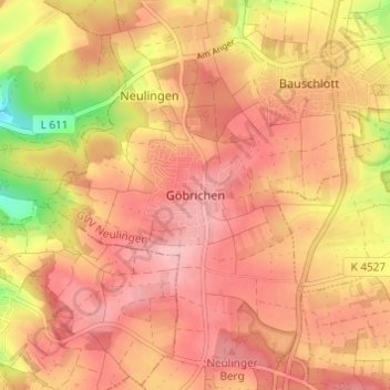
Name: Göbrichen topographic map, elevation, terrain.
Average elevation: 1,070 ft
Minimum elevation: 771 ft
Maximum elevation: 1,207 ft
Other topographic maps
Click on a map to view its topography, its elevation and its terrain.
Tiefenbronn
Germany > Baden-Württemberg > Enzkreis
The municipality (Gemeinde) of Tiefenbronn covers 14.79 square kilometers (5.71 sq mi) of the Enzkreis, a district of Baden-Württemberg, Germany. It is located on the edge of the Black Forest and the Upper Gäu [de]. The buntsandstein of the Röt Formation, under the Black Forest, extends into the municipal…
Average elevation: 1,470 ft
Wiernsheim
Germany > Baden-Württemberg > Enzkreis
The municipality (Gemeinde) of Wiernsheim covers 24.62 kilometers (15.30 mi) of the Enzkreis, a district of the state of Baden-Württemberg and the Federal Republic of Germany. It is located in the metropolitan areas of Karlsruhe and Pforzheim, along the southwestern edge of the Neckar basin [de]. Wiernsheim…
Average elevation: 1,175 ft
Heimsheim
Germany > Baden-Württemberg > Enzkreis
The township (Stadt) Heimsheim covers an area of 14.3 square kilometers (5.5 sq mi) at the very southeastern tip of the Enz district. It is physically located in the foothills of the Black Forest, in the Heckengäu, a region geology is characterized by karstified and wooded muschelkalk hills. Because the…
Average elevation: 1,476 ft
Neuenbürg
Germany > Baden-Württemberg > Enzkreis
The township (Stadt) of Neuenbürg covers 28.17 square kilometers (10.88 sq mi) of the Enz district, within the state of Baden-Württemberg and the Federal Republic of Germany. It is physically located on the Pfinzhügelland [de], on the southern reaches of the Kraichgau. The geological makeup of the municipal…
Average elevation: 1,699 ft
Illingen
Germany > Baden-Württemberg > Enzkreis
The municipality (Gemeinde) of Illingen is located at the eastern edge of the Enzkreis district, within the state of Baden-Württemberg and Federal Republic of Germany. It covers an area of 29.36 square kilometers (11.34 sq mi) that lies within the metropolitan areas of Karlsruhe and Pforzheim. Illingen is…
Average elevation: 915 ft
Wimsheim
Germany > Baden-Württemberg > Enzkreis
The municipality (Gemeinde) of Wimsheim covers 8.06 square kilometers (3.11 sq mi) of the Enz district of Baden-Württemberg, a state of the Federal Republic of Germany. Wimsheim is located in the metropolitan areas of Pforzheim and Karlsruhe and on the edge of the Black Forest, the Neckar basin [de], and the…
Average elevation: 1,437 ft