Geolocate

Nerja topographic map

Click on the map to display elevation.

About this map

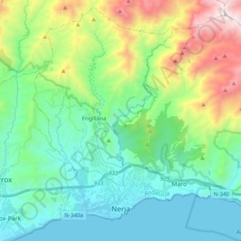
Name: Nerja topographic map, elevation, terrain.

Location: Nerja, La Axarquía, Malaga, Andalusia, Spain (36.73756 -3.91351 36.84184 -3.76597)

Average elevation: 1,591 ft

Minimum elevation: -3 ft

Maximum elevation: 5,984 ft

Other topographic maps

Click on a map to view its topography, its elevation and its terrain.

Torrox Park

Spain > Andalusia > La Axarquía > Torrox

Average elevation: 236 ft

Maroma

Spain > Andalusia > La Axarquía > Canillas de Aceituno

La Maroma, also known as Tejeda, at an altitude of 2069 m, is the highest peak of the Sierra de Tejeda, Penibaetic System, Spain. The summit is located in the region of Axarquía on the border between the provinces of Granada and Málaga.

Average elevation: 5,597 ft

Torre del Mar

Spain > Andalusia > La Axarquía > Vélez-Málaga

Average elevation: 33 ft

Almayate

Spain > Andalusia > La Axarquía > Vélez-Málaga

Average elevation: 131 ft

Las Mayorales

Spain > Andalusia > La Axarquía > Periana

Average elevation: 1,066 ft

Generación del 27

Spain > Andalusia > La Axarquía > Torrox > Los Llanos

Average elevation: 177 ft

Torrox

Spain > Andalusia > La Axarquía > Torrox

Average elevation: 436 ft

La Torre

Spain > Andalusia > La Axarquía > Benamargosa

Average elevation: 1,135 ft

Frigiliana

Spain > Andalusia > La Axarquía > Frigiliana > Frigiliana

Average elevation: 1,076 ft

Gear up for your next adventure:

🎁Geography Themed Gifts - Unique gift ideas for map lovers and geography enthusiasts
📦Gear Storage Bags - Organize and protect outdoor equipment
🥤Water Filter Bottle - All‑in‑one filter bottle for safe hydration
👖Convertible Hiking Pants - Versatile zip-off pants for changing altitudes and temperatures
🥇GPS Hiking Watch - Multi‑sport GPS watch with navigation and trail tracking

As an Amazon Associate, this site earns from qualifying purchases at no extra cost to you.