
Make a donation
Gear up for your next adventure:
As an Amazon Associate, this site earns from qualifying purchases at no extra cost to you.
West End topographic map
Click on the map to display elevation.
Make a donation
Gear up for your next adventure:
As an Amazon Associate, this site earns from qualifying purchases at no extra cost to you.
About this map
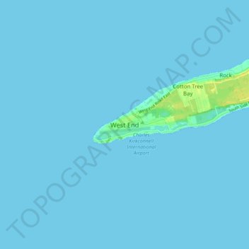
Name: West End topographic map, elevation, terrain.
Location: West End, Sister Islands, Cayman Islands (19.64878 -79.92285 19.72878 -79.84285)
Average elevation: 3 ft
Minimum elevation: 0 ft
Maximum elevation: 59 ft
Make a donation
Gear up for your next adventure:
As an Amazon Associate, this site earns from qualifying purchases at no extra cost to you.
Other topographic maps
Click on a map to view its topography, its elevation and its terrain.
Little Cayman
Little Cayman is one of three Islands that make up the Cayman Islands. It is located in the Caribbean Sea, approximately 60 miles (96 km) northeast of East End, Grand Cayman and five miles (8 km) west of West End, Cayman Brac. Little Cayman is the least populous island of the three, with a permanent population…
Average elevation: 3 ft
Make a donation
Gear up for your next adventure:
As an Amazon Associate, this site earns from qualifying purchases at no extra cost to you.