
Make a donation
Gear up for your next adventure:
As an Amazon Associate, this site earns from qualifying purchases at no extra cost to you.
Bács-Kiskun topographic map
Click on the map to display elevation.
Make a donation
Gear up for your next adventure:
As an Amazon Associate, this site earns from qualifying purchases at no extra cost to you.
Bács-Kiskun
Bács-Kiskun lies on the Great Hungarian Plain. The difference between its highest and lowest elevations is only 80 m.
Make a donation
Gear up for your next adventure:
As an Amazon Associate, this site earns from qualifying purchases at no extra cost to you.
About this map
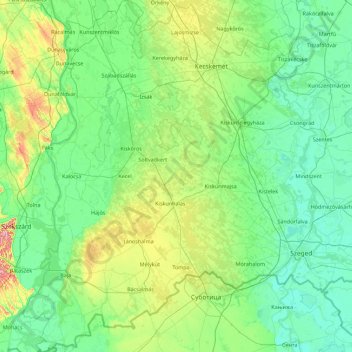
Name: Bács-Kiskun topographic map, elevation, terrain.
Location: Bács-Kiskun, South Great Plain, Great Plain and North, Hungary (45.90479 18.73307 47.13438 20.16009)
Average elevation: 341 ft
Minimum elevation: 240 ft
Maximum elevation: 906 ft
Make a donation
Gear up for your next adventure:
As an Amazon Associate, this site earns from qualifying purchases at no extra cost to you.
Other topographic maps
Click on a map to view its topography, its elevation and its terrain.
Make a donation
Gear up for your next adventure:
As an Amazon Associate, this site earns from qualifying purchases at no extra cost to you.
Make a donation
Gear up for your next adventure:
As an Amazon Associate, this site earns from qualifying purchases at no extra cost to you.
Make a donation
Gear up for your next adventure:
As an Amazon Associate, this site earns from qualifying purchases at no extra cost to you.
Kékes
Kékes Peak is the highest altitude region in Hungary, so it has the highest altitude weather station in the country. Although the mountain is still classified as a temperate humid continental climate (Dfb) according to the Köppen climate classification, it is very close to a subarctic climate (Dfc). Unlike…
Average elevation: 2,680 ft
Make a donation
Gear up for your next adventure:
As an Amazon Associate, this site earns from qualifying purchases at no extra cost to you.
Make a donation
Gear up for your next adventure:
As an Amazon Associate, this site earns from qualifying purchases at no extra cost to you.
Make a donation
Gear up for your next adventure:
As an Amazon Associate, this site earns from qualifying purchases at no extra cost to you.
Make a donation
Gear up for your next adventure:
As an Amazon Associate, this site earns from qualifying purchases at no extra cost to you.
Make a donation
Gear up for your next adventure:
As an Amazon Associate, this site earns from qualifying purchases at no extra cost to you.
Pécs
Pécs is bordered by plains to the south (elevation 120–130 m), while the Mecsek mountains rise up to elevations of 400–600 meters behind the city. Jakab-hill, located in the western Mecsek, is 592 m (1942 ft) tall, Tubes, straight above Pécs, is 612 m (2008 ft) tall, and Misina is 535 m (1755 ft) tall.…
Average elevation: 689 ft
Make a donation
Gear up for your next adventure:
As an Amazon Associate, this site earns from qualifying purchases at no extra cost to you.