
Woss topographic map
Click on the map to display elevation.
About this map
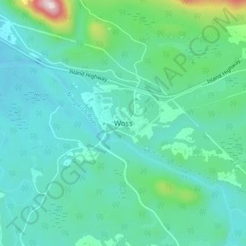
Name: Woss topographic map, elevation, terrain.
Average elevation: 656 ft
Minimum elevation: 374 ft
Maximum elevation: 2,014 ft
Other topographic maps
Click on a map to view its topography, its elevation and its terrain.
Rice Lake
Canada > British Columbia > Regional District of Mount Waddington > Area D (Nimpkish Valley/Cormorant Island) > Woss
Average elevation: 768 ft
Nimpkish Lake Provincial Park
Canada > British Columbia > Regional District of Mount Waddington > Area D (Nimpkish Valley/Cormorant Island)
Average elevation: 2,149 ft
Newcastle Ridge
Canada > British Columbia > Regional District of Mount Waddington > Area D (Nimpkish Valley/Cormorant Island)
Average elevation: 3,435 ft
Eve River
Canada > British Columbia > Regional District of Mount Waddington > Area D (Nimpkish Valley/Cormorant Island)
Average elevation: 1,873 ft
Nimpkish Lake Provincial Park
Canada > British Columbia > Regional District of Mount Waddington > Area D (Nimpkish Valley/Cormorant Island)
Average elevation: 2,149 ft