
Klemtu topographic map
Click on the map to display elevation.
About this map
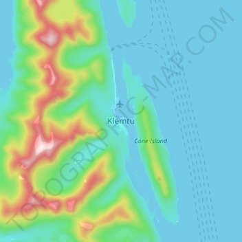
Name: Klemtu topographic map, elevation, terrain.
Average elevation: 499 ft
Minimum elevation: -3 ft
Maximum elevation: 2,661 ft
Other topographic maps
Click on a map to view its topography, its elevation and its terrain.
Bishop Bay
Canada > British Columbia > Regional District of Kitimat-Stikine > Area C (Butedale/Kitlope/Kitsumkalum)
Average elevation: 554 ft
Douglas Channel
Canada > British Columbia > Regional District of Kitimat-Stikine > Area C (Butedale/Kitlope/Kitsumkalum)
Average elevation: 1,079 ft
Kitsumkalum Lake
Canada > British Columbia > Regional District of Kitimat-Stikine > Area C (Butedale/Kitlope/Kitsumkalum) > Rosswood
Average elevation: 1,555 ft
Clearwater Lakes
Canada > British Columbia > Regional District of Kitimat-Stikine > Area C (Butedale/Kitlope/Kitsumkalum)
Average elevation: 656 ft
Deep Creek
Canada > British Columbia > Regional District of Kitimat-Stikine > Area C (Butedale/Kitlope/Kitsumkalum)
Average elevation: 436 ft
Gribbell Island
Canada > British Columbia > Regional District of Kitimat-Stikine > Area C (Butedale/Kitlope/Kitsumkalum)
Average elevation: 846 ft
Hawkesbury Island
Canada > British Columbia > Regional District of Kitimat-Stikine > Area C (Butedale/Kitlope/Kitsumkalum)
Average elevation: 817 ft
Hawkesbury Island
Canada > British Columbia > Regional District of Kitimat-Stikine > Area C (Butedale/Kitlope/Kitsumkalum)
Average elevation: 817 ft