
Thank you for supporting this site ❤️
Make a donation
Make a donation
Gear up for your next adventure:
As an Amazon Associate, this site earns from qualifying purchases at no extra cost to you.
Deggendorf topographic map
Click on the map to display elevation.
Thank you for supporting this site ❤️
Make a donation
Make a donation
Gear up for your next adventure:
As an Amazon Associate, this site earns from qualifying purchases at no extra cost to you.
About this map
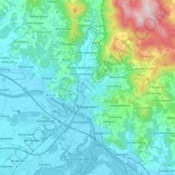
Name: Deggendorf topographic map, elevation, terrain.
Location: Deggendorf, Landkreis Deggendorf, Bavaria, 94469, Germany (48.78686 12.87356 48.90861 13.07415)
Average elevation: 1,473 ft
Minimum elevation: 1,014 ft
Maximum elevation: 3,612 ft
Thank you for supporting this site ❤️
Make a donation
Make a donation
Gear up for your next adventure:
As an Amazon Associate, this site earns from qualifying purchases at no extra cost to you.