
Charing topographic map
Click on the map to display elevation.
About this map
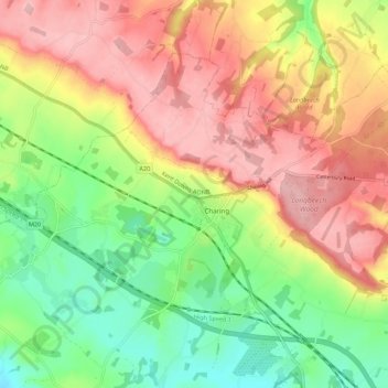
Name: Charing topographic map, elevation, terrain.
Location: Charing, Ashford, Kent, England, United Kingdom (51.18929 0.74004 51.23937 0.84950)
Average elevation: 400 ft
Minimum elevation: 151 ft
Maximum elevation: 650 ft
Other topographic maps
Click on a map to view its topography, its elevation and its terrain.
Odiam wood
United Kingdom > England > Kent > Ashford > Bethersden > Wissenden
Average elevation: 112 ft
Ham Street Woods National Nature Reserve
United Kingdom > England > Kent > Ashford > Hamstreet
Average elevation: 102 ft
Wye National Nature Reserve
United Kingdom > England > Kent > Ashford > Brook
Average elevation: 404 ft