Geolocate

Hinxhill topographic map

Click on the map to display elevation.

About this map

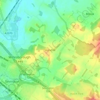
Name: Hinxhill topographic map, elevation, terrain.

Location: Hinxhill, Ashford, Kent, England, TN25 5NR, United Kingdom (51.12582 0.90827 51.16582 0.94827)

Average elevation: 167 ft

Minimum elevation: 95 ft

Maximum elevation: 289 ft

Other topographic maps

Click on a map to view its topography, its elevation and its terrain.

Chilham

United Kingdom > England > Kent > Ashford

Average elevation: 240 ft

Wittersham

United Kingdom > England > Kent > Ashford

Average elevation: 59 ft

Smarden

United Kingdom > England > Kent > Ashford

Average elevation: 102 ft

Kingsnorth

United Kingdom > England > Kent > Ashford

Average elevation: 141 ft

Rolvenden

United Kingdom > England > Kent > Ashford

Average elevation: 102 ft

Biddenden

United Kingdom > England > Kent > Ashford

Average elevation: 151 ft

Tenterden

United Kingdom > England > Kent > Ashford

Average elevation: 92 ft

Challock

United Kingdom > England > Kent > Ashford

Average elevation: 446 ft

Bethersden

United Kingdom > England > Kent > Ashford

Average elevation: 125 ft

Gear up for your next adventure:

🎒Waterproof Dry Bags - Keep your electronics and maps dry inside your pack
⛑️Personal Locator Beacon - Safety beacon for emergencies
🛰️Handheld GPS Units - Professional satellite navigators for precise backcountry mapping
🧭Map Reading Tools - Tools and kits for map navigation
🪶Thermal Camp Blanket - Extra warmth for cold nights

As an Amazon Associate, this site earns from qualifying purchases at no extra cost to you.