
Make a donation
Gear up for your next adventure:
As an Amazon Associate, this site earns from qualifying purchases at no extra cost to you.
Eno River topographic map
Click on the map to display elevation.
Make a donation
Gear up for your next adventure:
As an Amazon Associate, this site earns from qualifying purchases at no extra cost to you.
About this map
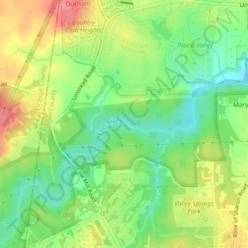
Name: Eno River topographic map, elevation, terrain.
Average elevation: 440 ft
Minimum elevation: 328 ft
Maximum elevation: 577 ft
Durham County trails, hiking, mountain biking, running and outdoor activities
Make a donation
Gear up for your next adventure:
As an Amazon Associate, this site earns from qualifying purchases at no extra cost to you.
Other topographic maps
Click on a map to view its topography, its elevation and its terrain.
Falls Lake
United States > North Carolina > Durham County
Work on the dam that holds the lake began in 1978 and was completed in 1981. Prior to its construction flooding of the Neuse River caused extensive damage to public and private properties including roadways, railroads, industrial sites and farmlands. The U.S. Army Corps of Engineers constructed and manages the…
Average elevation: 331 ft
Make a donation
Gear up for your next adventure:
As an Amazon Associate, this site earns from qualifying purchases at no extra cost to you.
Make a donation
Gear up for your next adventure:
As an Amazon Associate, this site earns from qualifying purchases at no extra cost to you.