
Make a donation
Gear up for your next adventure:
As an Amazon Associate, this site earns from qualifying purchases at no extra cost to you.
Turkey Creek topographic map
Click on the map to display elevation.
Make a donation
Gear up for your next adventure:
As an Amazon Associate, this site earns from qualifying purchases at no extra cost to you.
About this map
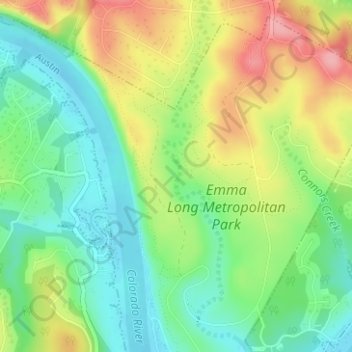
Name: Turkey Creek topographic map, elevation, terrain.
Location: Turkey Creek, Austin, Travis County, Texas, United States (30.33075 -97.84207 30.35575 -97.83556)
Average elevation: 650 ft
Minimum elevation: 495 ft
Maximum elevation: 873 ft
Make a donation
Gear up for your next adventure:
As an Amazon Associate, this site earns from qualifying purchases at no extra cost to you.
Other topographic maps
Click on a map to view its topography, its elevation and its terrain.
Circle C Ranch Metropolitan Park on Slaughter Creek
United States > Texas > Travis County > Austin
Average elevation: 850 ft
Shoal Beach at Town Lake Metropolitan Park
United States > Texas > Travis County > Austin
Average elevation: 499 ft
Walter E. Long Metropolitan Park
United States > Texas > Travis County > Austin
Average elevation: 571 ft
Make a donation
Gear up for your next adventure:
As an Amazon Associate, this site earns from qualifying purchases at no extra cost to you.
Austin
United States > Texas > Travis County > Austin
The elevation of Austin varies from 425 feet (130 m) to approximately 1,000 feet (305 m) above sea level. Due to the fact it straddles the Balcones Fault, much of the eastern part of the city is flat, with heavy clay and loam soils, whereas the western part and western suburbs consist of rolling hills on the…
Average elevation: 666 ft
Make a donation
Gear up for your next adventure:
As an Amazon Associate, this site earns from qualifying purchases at no extra cost to you.
Make a donation
Gear up for your next adventure:
As an Amazon Associate, this site earns from qualifying purchases at no extra cost to you.