
Sprinkle Corner topographic map
Click on the map to display elevation.
About this map
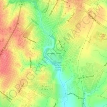
Name: Sprinkle Corner topographic map, elevation, terrain.
Average elevation: 663 ft
Minimum elevation: 531 ft
Maximum elevation: 768 ft
Other topographic maps
Click on a map to view its topography, its elevation and its terrain.
Circle C Ranch Metropolitan Park on Slaughter Creek
United States > Texas > Travis County > Austin
Average elevation: 850 ft
Roy G. Guerrero Colorado River Metro Park
United States > Texas > Travis County > Austin
Average elevation: 463 ft
Shoal Beach at Town Lake Metropolitan Park
United States > Texas > Travis County > Austin
Average elevation: 499 ft
Walter E. Long Metropolitan Park
United States > Texas > Travis County > Austin
Average elevation: 571 ft