
Make a donation
Gear up for your next adventure:
As an Amazon Associate, this site earns from qualifying purchases at no extra cost to you.
Elchingen topographic map
Click on the map to display elevation.
Make a donation
Gear up for your next adventure:
As an Amazon Associate, this site earns from qualifying purchases at no extra cost to you.
About this map
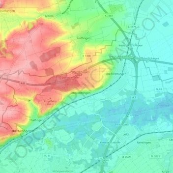
Name: Elchingen topographic map, elevation, terrain.
Location: Elchingen, Landkreis Neu-Ulm, Bayern, 89275, Deutschland (48.42752 10.02790 48.47760 10.14249)
Average elevation: 1,604 ft
Minimum elevation: 1,467 ft
Maximum elevation: 1,883 ft
Make a donation
Gear up for your next adventure:
As an Amazon Associate, this site earns from qualifying purchases at no extra cost to you.
Other topographic maps
Click on a map to view its topography, its elevation and its terrain.
Make a donation
Gear up for your next adventure:
As an Amazon Associate, this site earns from qualifying purchases at no extra cost to you.
Illereichen
Deutschland > Bayern > Landkreis Neu-Ulm
Der Sitz der Herrschaft Aichheim (auch Aichen) war 1330 nach dem Tod des letzten Aichheimers, Berthold, durch Erbschaft an die Herren von Rechberg übergegangen und bald danach auf das Areal des heutigen Schloßberges in Illereichen verlegt worden. Im Anschluss an die sehr umfangreiche, vor allem im 15.…
Average elevation: 1,831 ft
Schloss
Deutschland > Bayern > Landkreis Neu-Ulm > Neu-Ulm > Holzschwang
Holzschwang liegt am östlichen Rande des Höhenzuges zwischen Iller und Roth auf einer Höhe zwischen 490 und 520 m ü. NN und bildet den süd-östlichst gelegenen Ortsteil Neu-Ulms. Die Entfernung zum Stadtzentrum beträgt rund 10 km über die unmittelbar am westlichen Ortsrand entlang verlaufende…
Average elevation: 1,650 ft
Make a donation
Gear up for your next adventure:
As an Amazon Associate, this site earns from qualifying purchases at no extra cost to you.
Make a donation
Gear up for your next adventure:
As an Amazon Associate, this site earns from qualifying purchases at no extra cost to you.
Make a donation
Gear up for your next adventure:
As an Amazon Associate, this site earns from qualifying purchases at no extra cost to you.
Make a donation
Gear up for your next adventure:
As an Amazon Associate, this site earns from qualifying purchases at no extra cost to you.
Wullenstetten
Deutschland > Bayern > Landkreis Neu-Ulm > Senden > Wullenstetten
Average elevation: 1,654 ft
Kellmünz an der Iller
Deutschland > Bayern > Landkreis Neu-Ulm > Kellmünz a.d.Iller
Average elevation: 1,844 ft
Make a donation
Gear up for your next adventure:
As an Amazon Associate, this site earns from qualifying purchases at no extra cost to you.