
Make a donation
Gear up for your next adventure:
As an Amazon Associate, this site earns from qualifying purchases at no extra cost to you.
Illereichen topographic map
Click on the map to display elevation.
Make a donation
Gear up for your next adventure:
As an Amazon Associate, this site earns from qualifying purchases at no extra cost to you.
Illereichen
Der Sitz der Herrschaft Aichheim (auch Aichen) war 1330 nach dem Tod des letzten Aichheimers, Berthold, durch Erbschaft an die Herren von Rechberg übergegangen und bald danach auf das Areal des heutigen Schloßberges in Illereichen verlegt worden. Im Anschluss an die sehr umfangreiche, vor allem im 15. Jahrhundert ausgebaute Burganlage entstand der neue Ort Illereichen auf der Höhe über dem alten Dorf, später „Altenstadt“ genannt. Im 15. Jahrhundert wurde nach dem Neubau der Illereicher Kirche Mariä Himmelfahrt auch der Pfarrsitz der Herrschaft hierher verlegt. Die Ortschaft Illereichen entwickelte sich zum befestigten Markt – ausgehend von einem Platz vor der Burg mit Pfarrhof und Amtshaus und der Höhenlinie des Bergsporns nach Nordosten folgend – beiderseits einer einzigen Straße, der Marktstraße. Ihr leicht geschwungener Verlauf ist in planmäßiger Reihung mit einfachen, meist zweigeschossigen traufständigen Häusern des 18. und frühen 19. Jahrhundert besetzt, die ein geschlossenes Bild einer Kleinbauern- und Handwerkersiedlung vermitteln.
Make a donation
Gear up for your next adventure:
As an Amazon Associate, this site earns from qualifying purchases at no extra cost to you.
About this map
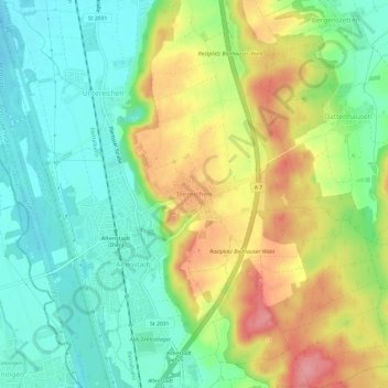
Name: Illereichen topographic map, elevation, terrain.
Average elevation: 1,831 ft
Minimum elevation: 1,693 ft
Maximum elevation: 2,034 ft
Make a donation
Gear up for your next adventure:
As an Amazon Associate, this site earns from qualifying purchases at no extra cost to you.
Other topographic maps
Click on a map to view its topography, its elevation and its terrain.
Illertissen
Deutschland > Bayern > Landkreis Neu-Ulm
Die Gemeinde liegt auf einer Höhe von 513 m ü. NHN im Südwesten des Bundeslandes Bayern im Regierungsbezirk Schwaben. Die Stadt hat ihren Namen von der unmittelbar an der westlichen Stadtgrenze vorbeifließenden Iller. Sie liegt etwa mittig zwischen Memmingen und Ulm.
Average elevation: 1,713 ft
Neu-Ulm
Deutschland > Bayern > Landkreis Neu-Ulm
Gemäß der Bundes-Immissionsschutzverordnung darf der Grenzwert für Feinstaub PM10 in Höhe von 50 µg/m³ (24-h-Wert) maximal 35-mal im Jahr überschritten werden. Durch die Ablagerung in der Lunge und der zusätzlichen Schadstoffbelastung stellen die Partikel eine ernsthafte Gesundheitsgefahr dar. An der…
Average elevation: 1,634 ft
Make a donation
Gear up for your next adventure:
As an Amazon Associate, this site earns from qualifying purchases at no extra cost to you.
Make a donation
Gear up for your next adventure:
As an Amazon Associate, this site earns from qualifying purchases at no extra cost to you.
Gerlenhofen
Deutschland > Bayern > Landkreis Neu-Ulm > Neu-Ulm
Das Pfarrdorf liegt 6 bis 7 km südlich des Stadtzentrums, auf einer Höhe von etwa 480 m ü. NN, zwischen Ludwigsfeld und der Nachbarstadt Senden (an der Iller), von der es durch die B 28 (der ehemaligen A 80) getrennt ist.
Average elevation: 1,604 ft
Make a donation
Gear up for your next adventure:
As an Amazon Associate, this site earns from qualifying purchases at no extra cost to you.
Schloss
Deutschland > Bayern > Landkreis Neu-Ulm > Neu-Ulm > Holzschwang
Holzschwang liegt am östlichen Rande des Höhenzuges zwischen Iller und Roth auf einer Höhe zwischen 490 und 520 m ü. NN und bildet den süd-östlichst gelegenen Ortsteil Neu-Ulms. Die Entfernung zum Stadtzentrum beträgt rund 10 km über die unmittelbar am westlichen Ortsrand entlang verlaufende…
Average elevation: 1,650 ft
Auwald
Deutschland > Bayern > Landkreis Neu-Ulm
Der Auwald liegt unmittelbar östlich der bayerischen Landesgrenze zu Baden-Württemberg auf einer Höhe von 498 bis 514 m ü. NN. Er erstreckt sich westlich und östlich der Iller von Flusskilometer 15,3 bis 23, somit über 7,7 Kilometer. Bei einer Fläche von 4,96 km² ergibt das eine durchschnittliche…
Average elevation: 1,749 ft
Make a donation
Gear up for your next adventure:
As an Amazon Associate, this site earns from qualifying purchases at no extra cost to you.
Bellenberg
Deutschland > Bayern > Landkreis Neu-Ulm
Bellenberg liegt etwa einen Kilometer östlich des bayerisch-württembergischen Grenzflusses Iller zwischen den Städten Vöhringen im Norden und Illertissen im Süden und 15 Kilometer südlich des Ballungsraumes Ulm/Neu-Ulm. Zu erreichen ist der Ort über die Bundesautobahn 7, die Staatsstraße 2031 und die…
Average elevation: 1,686 ft
Make a donation
Gear up for your next adventure:
As an Amazon Associate, this site earns from qualifying purchases at no extra cost to you.
Stoffenrieder Forst
Deutschland > Bayern > Landkreis Neu-Ulm
Das Gebiet wird hauptsächlich forstwirtschaftlich genutzt. Am westlichen Rand des Gebietes in Höhe Wallenhausen befinden sich Brunnen und ein Hochbehälter des Zweckverbandes zur Wasserversorgung Rauher-Berg-Gruppe. Im südöstlichen Teil des Gebietes ist eine Fläche als Wasserschutzgebiet ausgewiesen.
Average elevation: 1,673 ft
Make a donation
Gear up for your next adventure:
As an Amazon Associate, this site earns from qualifying purchases at no extra cost to you.
Make a donation
Gear up for your next adventure:
As an Amazon Associate, this site earns from qualifying purchases at no extra cost to you.
Make a donation
Gear up for your next adventure:
As an Amazon Associate, this site earns from qualifying purchases at no extra cost to you.
89275
Deutschland > Bayern > Landkreis Neu-Ulm > Elchingen > Oberelchingen
Average elevation: 1,637 ft
Steinheim
Deutschland > Bayern > Landkreis Neu-Ulm > Neu-Ulm
Im Norden befindet sich der 493 Meter hohe Buchberg, ein Schwemmkegel vor dem glazialen Abflusstal der Donau, der den Ort um ca. 25 Meter überragt. Am Fuß des Hügel in südlicher Lage, befindet sich heute noch Überreste eines Bierkellers. Dieser unterstreicht die frühere Bedeutung der Anhöhe als…
Average elevation: 1,552 ft
Holzheim
Deutschland > Bayern > Landkreis Neu-Ulm
2017 gab es in der Gemeinde 122 sozialversicherungspflichtig Beschäftigte. Von den Einwohnern standen 835 Personen in einer versicherungspflichtigen Beschäftigung. Damit lag die Zahl der Auspendler um 713 höher als die der Einpendler. Arbeitslos waren 16 Einwohner.
Average elevation: 1,588 ft
Make a donation
Gear up for your next adventure:
As an Amazon Associate, this site earns from qualifying purchases at no extra cost to you.
Bellenberg
Deutschland > Bayern > Landkreis Neu-Ulm
Bellenberg liegt etwa einen Kilometer östlich des bayerisch-württembergischen Grenzflusses Iller zwischen den Städten Vöhringen im Norden und Illertissen im Süden und 15 Kilometer südlich des Ballungsraumes Ulm/Neu-Ulm. Zu erreichen ist der Ort über die Bundesautobahn 7, die Staatsstraße 2031 und die…
Average elevation: 1,686 ft
Neu-Ulm
Deutschland > Bayern > Landkreis Neu-Ulm
Gemäß der Bundes-Immissionsschutzverordnung darf der Grenzwert für Feinstaub PM10 in Höhe von 50 µg/m³ (24-h-Wert) maximal 35-mal im Jahr überschritten werden. Durch die Ablagerung in der Lunge und der zusätzlichen Schadstoffbelastung stellen die Partikel eine ernsthafte Gesundheitsgefahr dar. An der…
Average elevation: 1,637 ft
Make a donation
Gear up for your next adventure:
As an Amazon Associate, this site earns from qualifying purchases at no extra cost to you.