
Make a donation
Gear up for your next adventure:
As an Amazon Associate, this site earns from qualifying purchases at no extra cost to you.
Yulin topographic map
Click on the map to display elevation.
Make a donation
Gear up for your next adventure:
As an Amazon Associate, this site earns from qualifying purchases at no extra cost to you.
About this map
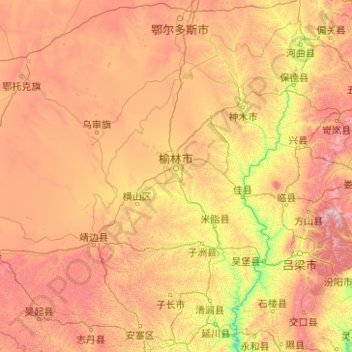
Name: Yulin topographic map, elevation, terrain.
Location: Yulin, Shaanxi, China (36.81606 107.25112 39.58494 111.24248)
Average elevation: 4,170 ft
Minimum elevation: 1,995 ft
Maximum elevation: 8,990 ft
Make a donation
Gear up for your next adventure:
As an Amazon Associate, this site earns from qualifying purchases at no extra cost to you.
Other topographic maps
Click on a map to view its topography, its elevation and its terrain.
Xi'an
China > Shaanxi > Weiyang District > Xi'an
Xi'an lies on the Guanzhong Plain in the south-central part of Shaanxi province, on a flood plain created by the eight surrounding rivers and streams. The city has an average elevation of 400 metres (1,312 ft) above sea level and an annual precipitation of 553 mm (21.8 in). The urban area of Xi'an is located…
Average elevation: 1,352 ft
Huanglong
Huanglong County is located approximately 221 kilometres (137 mi) from Yan'an's urban core, and 226 kilometres (140 mi) from Xi'an's urban core. Located in the Loess Plateau, Huanglong County is hilly in elevation, ranging from 643.7 metres (2,112 ft) to 1,738 metres (5,702 ft) in height. A number of minor…
Average elevation: 4,423 ft
Make a donation
Gear up for your next adventure:
As an Amazon Associate, this site earns from qualifying purchases at no extra cost to you.
Make a donation
Gear up for your next adventure:
As an Amazon Associate, this site earns from qualifying purchases at no extra cost to you.
Make a donation
Gear up for your next adventure:
As an Amazon Associate, this site earns from qualifying purchases at no extra cost to you.