Geolocate

Catrine topographic map

Click on the map to display elevation.

About this map

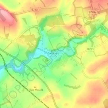
Name: Catrine topographic map, elevation, terrain.

Location: Catrine, East Ayrshire, Scotland, KA5 6RA, United Kingdom (55.48433 -4.35183 55.52433 -4.31183)

Average elevation: 456 ft

Minimum elevation: 272 ft

Maximum elevation: 646 ft

Other topographic maps

Click on a map to view its topography, its elevation and its terrain.

Glenbuck Loch

United Kingdom > Scotland > East Ayrshire

Average elevation: 1,073 ft

River Doon

United Kingdom > Scotland > East Ayrshire > Dalrymple

Average elevation: 551 ft

River Ayr

United Kingdom > Scotland > East Ayrshire

Average elevation: 689 ft

Braid Wood

United Kingdom > Scotland > East Ayrshire

Average elevation: 374 ft

Loch Doon

United Kingdom > Scotland > East Ayrshire

Average elevation: 955 ft

Gear up for your next adventure:

📖Nature Tracking Books - Learn to track wildlife and terrain
Camping Coffee Makers - Enjoy premium coffee at the summit or campsite
🛡️Bear Spray Outdoor - Protection in bear country hikes
🧴Hand Sanitizer - Keep hands clean while hiking
🧭Compass with Lanyard - Easy‑carry compass for navigation

As an Amazon Associate, this site earns from qualifying purchases at no extra cost to you.