
Make a donation
Gear up for your next adventure:
As an Amazon Associate, this site earns from qualifying purchases at no extra cost to you.
Tychy topographic map
Click on the map to display elevation.
Make a donation
Gear up for your next adventure:
As an Amazon Associate, this site earns from qualifying purchases at no extra cost to you.
About this map
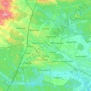
Name: Tychy topographic map, elevation, terrain.
Location: Tychy, Metropolis GZM, Silesian Voivodeship, Poland (50.07717 18.92527 50.17583 19.09152)
Average elevation: 840 ft
Minimum elevation: 755 ft
Maximum elevation: 1,099 ft
Make a donation
Gear up for your next adventure:
As an Amazon Associate, this site earns from qualifying purchases at no extra cost to you.
Other topographic maps
Click on a map to view its topography, its elevation and its terrain.
Make a donation
Gear up for your next adventure:
As an Amazon Associate, this site earns from qualifying purchases at no extra cost to you.
Make a donation
Gear up for your next adventure:
As an Amazon Associate, this site earns from qualifying purchases at no extra cost to you.
Make a donation
Gear up for your next adventure:
As an Amazon Associate, this site earns from qualifying purchases at no extra cost to you.
Make a donation
Gear up for your next adventure:
As an Amazon Associate, this site earns from qualifying purchases at no extra cost to you.
Make a donation
Gear up for your next adventure:
As an Amazon Associate, this site earns from qualifying purchases at no extra cost to you.
Zwardoń
Poland > Silesian Voivodeship > Żywiec County
Zwardoń, located at the elevation of 690 meters above sea level, is placed between three mountain passes - Przysłop, Zwardońska and Graniczne. Until 1975, the village was administratively tied with Kraków and Lesser Poland. In 1975 - 1999, it belonged to Bielsko-Biala Voivodeship, and after the territorial…
Average elevation: 2,329 ft
Strzyżowice - Biska
Poland > Silesian Voivodeship > Będzin County > Brzękowice-Wał
Average elevation: 1,093 ft
Make a donation
Gear up for your next adventure:
As an Amazon Associate, this site earns from qualifying purchases at no extra cost to you.
Młyńsko
Poland > Silesian Voivodeship > Żywiec County > Międzybrodzie Bialskie
Average elevation: 1,490 ft
Make a donation
Gear up for your next adventure:
As an Amazon Associate, this site earns from qualifying purchases at no extra cost to you.
Bielsko-Biała
Poland > Silesian Voivodeship > Bielsko-Biała > Bielsko-Biała
Average elevation: 1,306 ft
Wilamowice
Poland > Silesian Voivodeship > Bielsko County > Wilamowice > Wilamowice
Average elevation: 896 ft
Make a donation
Gear up for your next adventure:
As an Amazon Associate, this site earns from qualifying purchases at no extra cost to you.
Pustki
Poland > Silesian Voivodeship > Bielsko County > Mazańcowice > Pustki
Average elevation: 1,027 ft
Make a donation
Gear up for your next adventure:
As an Amazon Associate, this site earns from qualifying purchases at no extra cost to you.