
Chesnee topographic map
Click on the map to display elevation.
About this map
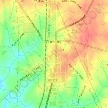
Name: Chesnee topographic map, elevation, terrain.
Location: Chesnee, Spartanburg County, South Carolina, United States (35.13231 -81.87393 35.15839 -81.85346)
Average elevation: 886 ft
Minimum elevation: 784 ft
Maximum elevation: 958 ft
Spartanburg County trails, hiking, mountain biking, running and outdoor activities
Other topographic maps
Click on a map to view its topography, its elevation and its terrain.
Croft State Park
United States > South Carolina > Spartanburg County > Pauline
Average elevation: 679 ft
East Spartanburg
United States > South Carolina > Spartanburg County > Spartanburg
Average elevation: 745 ft
East Spartanburg
United States > South Carolina > Spartanburg County > Spartanburg
Average elevation: 745 ft
Spartanburg
United States > South Carolina > Spartanburg County > Spartanburg
Average elevation: 768 ft