
Make a donation
Gear up for your next adventure:
As an Amazon Associate, this site earns from qualifying purchases at no extra cost to you.
Montefortino topographic map
Click on the map to display elevation.
Make a donation
Gear up for your next adventure:
As an Amazon Associate, this site earns from qualifying purchases at no extra cost to you.
Montefortino
Il paese è sito in posizione digradante dal versante sud-occidentale di un colle sulla destra del fiume Tenna. È abbracciato dall'anfiteatro dei Monti Sibillini cui se ne scorgono in ampi panorami i più alti picchi: dal Monte Vettore a sud, al Monte Sibilla, al Monte Priora (tutti superanti i 2000 metri d'altitudine), fino al Monte Amandola e in lontananza verso nord il Pizzo di Meta.
Make a donation
Gear up for your next adventure:
As an Amazon Associate, this site earns from qualifying purchases at no extra cost to you.
About this map
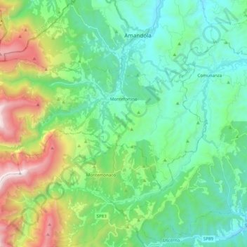
Name: Montefortino topographic map, elevation, terrain.
Location: Montefortino, Fermo, Marche, 63858, Italia (42.89016 13.21604 42.96728 13.41121)
Average elevation: 2,710 ft
Minimum elevation: 1,165 ft
Maximum elevation: 7,064 ft
Make a donation
Gear up for your next adventure:
As an Amazon Associate, this site earns from qualifying purchases at no extra cost to you.
Other topographic maps
Click on a map to view its topography, its elevation and its terrain.
Make a donation
Gear up for your next adventure:
As an Amazon Associate, this site earns from qualifying purchases at no extra cost to you.