Geolocate

Montebello topographic map

Click on the map to display elevation.

About this map

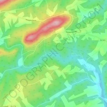
Name: Montebello topographic map, elevation, terrain.

Location: Montebello, Perry County, Pennsylvania, United States (40.40814 -77.09359 40.44814 -77.05359)

Average elevation: 607 ft

Minimum elevation: 384 ft

Maximum elevation: 1,001 ft

Other topographic maps

Click on a map to view its topography, its elevation and its terrain.

Duncannon

United States > Pennsylvania > Perry County

Average elevation: 453 ft

Rye Township

United States > Pennsylvania > Perry County

Average elevation: 600 ft

Newport

United States > Pennsylvania > Perry County

Average elevation: 486 ft

Toboyne Township

United States > Pennsylvania > Perry County

Average elevation: 1,250 ft

Millerstown

United States > Pennsylvania > Perry County

Average elevation: 617 ft

Blain

United States > Pennsylvania > Perry County

According to the United States Census Bureau, the borough has a total area of 0.3 square miles (0.78 km2), all land. Population is 286 (2000). Its highest point is Conegeuege Mountain (1872 feet); the elevation is 750 feet on average.

Average elevation: 745 ft

Liverpool

United States > Pennsylvania > Perry County

Average elevation: 486 ft

Duncannon

United States > Pennsylvania > Perry County

Average elevation: 453 ft

Landisburg

United States > Pennsylvania > Perry County

Average elevation: 630 ft

Marysville

United States > Pennsylvania > Perry County

Average elevation: 551 ft

Gear up for your next adventure:

🪶Survival Guide Book - Expert advice for emergency preparedness
🪶Paracord Bracelet - Survival bracelet with built‑in tools
🔭Compact Binoculars - HD vision for scouting terrain and identifying distant landmarks
🔭Stargazing Telescopes - Perfect for camping in low-light pollution areas shown on maps
🧥Waterproof Jacket for Hiking - Breathable and rugged rain jacket for outdoor excursions

As an Amazon Associate, this site earns from qualifying purchases at no extra cost to you.