
Make a donation
Gear up for your next adventure:
As an Amazon Associate, this site earns from qualifying purchases at no extra cost to you.
Oliver Township topographic map
Click on the map to display elevation.
Make a donation
Gear up for your next adventure:
As an Amazon Associate, this site earns from qualifying purchases at no extra cost to you.
About this map
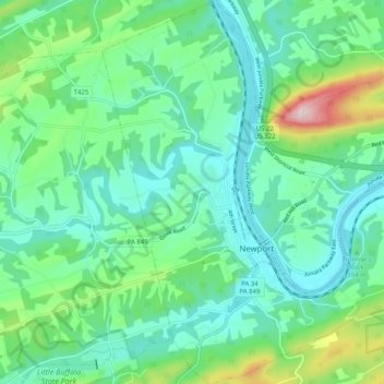
Name: Oliver Township topographic map, elevation, terrain.
Location: Oliver Township, Perry County, Pennsylvania, United States (40.45054 -77.17130 40.52756 -77.10211)
Average elevation: 604 ft
Minimum elevation: 341 ft
Maximum elevation: 1,453 ft
Make a donation
Gear up for your next adventure:
As an Amazon Associate, this site earns from qualifying purchases at no extra cost to you.
Other topographic maps
Click on a map to view its topography, its elevation and its terrain.
Shermans Dale
United States > Pennsylvania > Perry County > Carroll Township
Average elevation: 561 ft
Make a donation
Gear up for your next adventure:
As an Amazon Associate, this site earns from qualifying purchases at no extra cost to you.