
Euxton topographic map
Click on the map to display elevation.
About this map
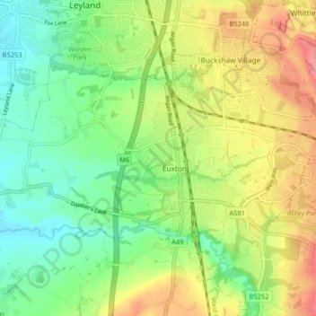
Name: Euxton topographic map, elevation, terrain.
Location: Euxton, Chorley, Lancashire, England, United Kingdom (53.65252 -2.72081 53.68191 -2.63997)
Average elevation: 164 ft
Minimum elevation: 52 ft
Maximum elevation: 318 ft
Other topographic maps
Click on a map to view its topography, its elevation and its terrain.
Coppull
United Kingdom > England > Lancashire > Chorley
The settlement has an Anglo Saxon name describing its topography derived from the Old English copp a hill top and hyll a hill. The township was variously recorded as Cophull and Cophulle in 1277, Copphull in 1351, Copthull in 1374 and Coppull from 1444.
Average elevation: 259 ft