Geolocate

Coppull topographic map

Click on the map to display elevation.

Coppull

The settlement has an Anglo Saxon name describing its topography derived from the Old English copp a hill top and hyll a hill. The township was variously recorded as Cophull and Cophulle in 1277, Copphull in 1351, Copthull in 1374 and Coppull from 1444.

Wikipedia (CC-BY-SA 3.0)

About this map

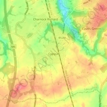
Name: Coppull topographic map, elevation, terrain.

Location: Coppull, Chorley, Lancashire, England, PR7 5BY, United Kingdom (53.60179 -2.68174 53.64179 -2.64174)

Average elevation: 259 ft

Minimum elevation: 125 ft

Maximum elevation: 364 ft

Other topographic maps

Click on a map to view its topography, its elevation and its terrain.

Euxton

United Kingdom > England > Lancashire > Chorley

Average elevation: 164 ft

Adlington

United Kingdom > England > Lancashire > Chorley

Average elevation: 312 ft

Gear up for your next adventure:

🪶Compact Camp Shovel - Folding shovel for campsite tasks
💧Water Purification System - Clean water on the trail with reliable purifiers
🗻Climbing Gear Basics - Essential gear for beginner climbers
🔭Compact Binoculars - HD vision for scouting terrain and identifying distant landmarks
🎁Geography Themed Gifts - Unique gift ideas for map lovers and geography enthusiasts

As an Amazon Associate, this site earns from qualifying purchases at no extra cost to you.