Geolocate

High Bank Lake topographic map

Click on the map to display elevation.

About this map

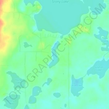
Name: High Bank Lake topographic map, elevation, terrain.

Location: High Bank Lake, Cass County, Minnesota, United States (46.95002 -94.49897 46.95684 -94.49479)

Average elevation: 1,394 ft

Minimum elevation: 1,352 ft

Maximum elevation: 1,506 ft

Cass County trails, hiking, mountain biking, running and outdoor activities

Other topographic maps

Click on a map to view its topography, its elevation and its terrain.

Birch Lake

United States > Minnesota > Cass County > Hackensack

Average elevation: 1,394 ft

Whipholt

United States > Minnesota > Cass County

Average elevation: 1,322 ft

Moose Lake

United States > Minnesota > Cass County

Average elevation: 1,450 ft

Inguadona

United States > Minnesota > Cass County

Average elevation: 1,325 ft

Boy Lake

United States > Minnesota > Cass County

Average elevation: 1,312 ft

Leech Lake

United States > Minnesota > Cass County

Average elevation: 1,325 ft

East Gull Lake

United States > Minnesota > Cass County

Average elevation: 1,214 ft

Bena

United States > Minnesota > Cass County > Bena

Average elevation: 1,306 ft

Hackensack

United States > Minnesota > Cass County > Hackensack

Average elevation: 1,388 ft

Pine River

United States > Minnesota > Cass County

Average elevation: 1,296 ft

Gear up for your next adventure:

📦Dry Bags Set - Waterproof storage for electronics and clothes
🧤Tactile Hiking Gloves - Keep hands warm while operating GPS and smartphone screens
🔥Camping Stove - Portable stove for camping and backcountry cooking
🔦Compact Flashlight - Reliable flashlight for emergencies
🎒Waterproof Dry Bags - Keep your electronics and maps dry inside your pack

As an Amazon Associate, this site earns from qualifying purchases at no extra cost to you.