
Headwaters State Forest topographic map
Click on the map to display elevation.
About this map
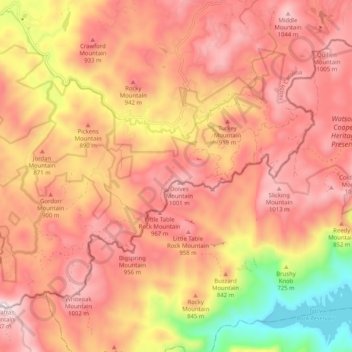
Name: Headwaters State Forest topographic map, elevation, terrain.
Average elevation: 2,684 ft
Minimum elevation: 1,237 ft
Maximum elevation: 3,514 ft
Transylvania County trails, hiking, mountain biking, running and outdoor activities
Other topographic maps
Click on a map to view its topography, its elevation and its terrain.
Knob Creek
United States > North Carolina > Transylvania County > Knob Creek
Average elevation: 2,411 ft
Line Runner Ridge
United States > North Carolina > Transylvania County > Line Runner Ridge
Average elevation: 2,697 ft
Franklin Park
United States > North Carolina > Transylvania County > Brevard > Franklin Park
Average elevation: 2,182 ft