
Make a donation
Gear up for your next adventure:
As an Amazon Associate, this site earns from qualifying purchases at no extra cost to you.
Salar de Ascotán topographic map
Click on the map to display elevation.
Make a donation
Gear up for your next adventure:
As an Amazon Associate, this site earns from qualifying purchases at no extra cost to you.
About this map
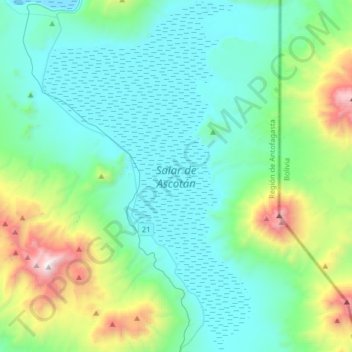
Name: Salar de Ascotán topographic map, elevation, terrain.
Average elevation: 13,530 ft
Minimum elevation: 12,106 ft
Maximum elevation: 19,505 ft
Make a donation
Gear up for your next adventure:
As an Amazon Associate, this site earns from qualifying purchases at no extra cost to you.
Other topographic maps
Click on a map to view its topography, its elevation and its terrain.
San Pedro de Atacama
Chile > Antofagasta Region > Provincia de El Loa
The town lies at an average of 8,000 feet (2,400 m), thus visitors often experience mild altitude sickness such as dizziness, lethargy and headaches. The local climate is extremely dry and mild, with daytime temperatures between 25–30 degrees Celsius (77–86 degrees Fahrenheit) in the summer (December to…
Average elevation: 11,247 ft
Calama
Chile > Antofagasta Region > Provincia de El Loa
The western boundary of the town of Calama is marked by the peaks of the foothills, which occurs north of Calama in the foothills of the Loa River, which has many names, from north to south: Sierra Moreno, Cerros Chuquicamata Cerros de Montecristo. The Cerro Poquis (4,589 m), is the maximum altitude, north of…
Average elevation: 8,704 ft
San Pedro de Atacama
Chile > Antofagasta Region > Provincia de El Loa
The town lies at an average of 8,000 feet (2,400 m), thus visitors often experience mild altitude sickness such as dizziness, lethargy and headaches. The local climate is extremely dry and mild, with daytime temperatures between 25–30 degrees Celsius (77–86 degrees Fahrenheit) in the summer (December to…
Average elevation: 11,247 ft
Make a donation
Gear up for your next adventure:
As an Amazon Associate, this site earns from qualifying purchases at no extra cost to you.
Camar
Chile > Antofagasta Region > Provincia de El Loa > San Pedro de Atacama
Average elevation: 8,930 ft
Socaire
Chile > Antofagasta Region > Provincia de El Loa > San Pedro de Atacama
Average elevation: 10,797 ft
A018
Chile > Antofagasta Region > Provincia de El Loa > San Pedro de Atacama > Atacama Large Millimeter/submillimeter Array
Average elevation: 16,473 ft
Volcán Ojos del Toro
Chile > Antofagasta Region > Provincia de El Loa > San Pedro de Atacama
Average elevation: 18,054 ft
Make a donation
Gear up for your next adventure:
As an Amazon Associate, this site earns from qualifying purchases at no extra cost to you.
Calama
Chile > Antofagasta Region > Provincia de El Loa
The western boundary of the town of Calama is marked by the peaks of the foothills, which occurs north of Calama in the foothills of the Loa River, which has many names, from north to south: Sierra Moreno, Cerros Chuquicamata Cerros de Montecristo. The Cerro Poquis (4,589 m), is the maximum altitude, north of…
Average elevation: 8,704 ft
Guatín
Chile > Antofagasta Region > Provincia de El Loa > San Pedro de Atacama
Average elevation: 10,745 ft
Lascar
Chile > Antofagasta Region > Provincia de El Loa > San Pedro de Atacama
Large lava flows are noticeable on the flanks of the volcano, with a total of eight lava flows recognized. They extend from the summit craters, although none of them appear to be associated with the currently active crater. Flows from the first stage of Lascar's activity are exposed at its western foot, while…
Average elevation: 17,287 ft
Make a donation
Gear up for your next adventure:
As an Amazon Associate, this site earns from qualifying purchases at no extra cost to you.
San Pedro de Atacama
Chile > Antofagasta Region > Provincia de El Loa
The town lies at an average of 8,000 feet (2,400 m), thus visitors often experience mild altitude sickness such as dizziness, lethargy and headaches. The local climate is extremely dry and mild, with daytime temperatures between 25–30 degrees Celsius (77–86 degrees Fahrenheit) in the summer (December to…
Average elevation: 11,247 ft
Valle de la Luna
Chile > Antofagasta Region > Provincia de El Loa > San Pedro de Atacama
Average elevation: 8,304 ft
Make a donation
Gear up for your next adventure:
As an Amazon Associate, this site earns from qualifying purchases at no extra cost to you.
Coyo
Chile > Antofagasta Region > Provincia de El Loa > San Pedro de Atacama
Average elevation: 7,864 ft
Atacama Large Millimeter/submillimeter Array
Chile > Antofagasta Region > Provincia de El Loa > San Pedro de Atacama > Atacama Large Millimeter/submillimeter Array
The Atacama Large Millimeter/submillimeter Array (ALMA) is an astronomical interferometer of 66 radio telescopes in the Atacama Desert of northern Chile, which observe electromagnetic radiation at millimeter and submillimeter wavelengths. The array has been constructed on the 5,000 m (16,000 ft) elevation…
Average elevation: 16,437 ft
Chaxas
Chile > Antofagasta Region > Provincia de El Loa > San Pedro de Atacama
Average elevation: 12,923 ft
Make a donation
Gear up for your next adventure:
As an Amazon Associate, this site earns from qualifying purchases at no extra cost to you.
View of astronomy array system to west
Chile > Antofagasta Region > Provincia de El Loa > San Pedro de Atacama
Average elevation: 15,253 ft