Geolocate

Staples Brook topographic map

Click on the map to display elevation.

About this map

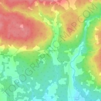
Name: Staples Brook topographic map, elevation, terrain.

Location: Staples Brook, Belmont, Municipality of Colchester, Colchester County, Nova Scotia, Canada (45.43180 -63.41600 45.47180 -63.37600)

Average elevation: 226 ft

Minimum elevation: 89 ft

Maximum elevation: 387 ft

Other topographic maps

Click on a map to view its topography, its elevation and its terrain.

Belmont

Canada > Nova Scotia > Municipality of Colchester

Average elevation: 308 ft

Pembroke

Canada > Nova Scotia > Municipality of Colchester

Average elevation: 361 ft

Clifton

Canada > Nova Scotia > Municipality of Colchester > Clifton

Average elevation: 102 ft

Gear up for your next adventure:

👟Men's Trail Runners - Lightweight footwear for fast-paced exploration and light hiking
🎒Trekking Poles - Sturdy poles for balance and stability on rough terrain
🧭Outdoor Navigation Book - Learn advanced navigation skills
🧤Hiking Gloves - Protective gloves for rugged trails
🛡️Insect Repellent - Protection against bugs during outdoor activities

As an Amazon Associate, this site earns from qualifying purchases at no extra cost to you.