Geolocate

Cadulawan topographic map

Click on the map to display elevation.

About this map

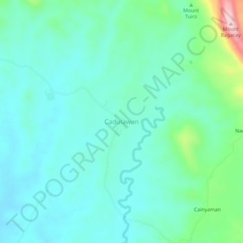
Name: Cadulawan topographic map, elevation, terrain.

Location: Cadulawan, Masbate, Bicol Region, Philippines (12.01081 123.90161 12.05081 123.94161)

Average elevation: 289 ft

Minimum elevation: 115 ft

Maximum elevation: 988 ft

Other topographic maps

Click on a map to view its topography, its elevation and its terrain.

Burias

Philippines > Masbate

Average elevation: 59 ft

Gear up for your next adventure:

🧦Hiking Socks - Comfortable socks to prevent blisters on long hikes
🪓Survival Multi‑Tool - Versatile tool for camp and trail tasks
🧭Map Reading Tools - Tools and kits for map navigation
🏕️Tent Footprint - Protect your tent base from wear
🧣Merino Neck Gaiters - Multi-functional headwear for wind and sun protection

As an Amazon Associate, this site earns from qualifying purchases at no extra cost to you.