Geolocate

Burias topographic map

Click on the map to display elevation.

About this map

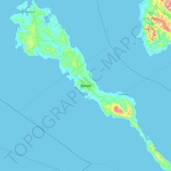
Name: Burias topographic map, elevation, terrain.

Location: Burias, Masbate, Bicol Region, 5420, Philippines (12.69359 122.92842 13.15915 123.38610)

Average elevation: 59 ft

Minimum elevation: 0 ft

Maximum elevation: 1,608 ft

Other topographic maps

Click on a map to view its topography, its elevation and its terrain.

Tanque

Philippines > Masbate

Average elevation: 72 ft

Masbate City

Philippines > Masbate

Average elevation: 223 ft

Cadulawan

Philippines > Masbate

Average elevation: 289 ft

Cabancalan

Philippines > Masbate

Average elevation: 108 ft

Monreal

Philippines > Masbate > Monreal

Average elevation: 203 ft

Gear up for your next adventure:

🧭Pro Hiking Compasses - High-accuracy liquid-filled compasses for topographic orientation
🔭Stargazing Telescopes - Perfect for camping in low-light pollution areas shown on maps
💧Water Filtration Bottles - Safely drink from streams and lakes while exploring
📡Handheld GPS Device - Reliable handheld GPS for outdoor navigation
🎒Hydration Pack - Hands‑free water reservoir for long hikes

As an Amazon Associate, this site earns from qualifying purchases at no extra cost to you.