
Make a donation
Gear up for your next adventure:
As an Amazon Associate, this site earns from qualifying purchases at no extra cost to you.
Dezhing Township topographic map
Click on the map to display elevation.
Make a donation
Gear up for your next adventure:
As an Amazon Associate, this site earns from qualifying purchases at no extra cost to you.
About this map
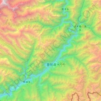
Name: Dezhing Township topographic map, elevation, terrain.
Average elevation: 8,862 ft
Minimum elevation: 1,959 ft
Maximum elevation: 23,504 ft
Make a donation
Gear up for your next adventure:
As an Amazon Associate, this site earns from qualifying purchases at no extra cost to you.
Other topographic maps
Click on a map to view its topography, its elevation and its terrain.
Medog
China > Tibet > Mêdog County > Medog Township
Due to the large elevation difference in the terrain, there are obvious vertical climate changes in the mountains. The annual sunshine hours in Medog County are 1500.7 hours, and the annual average temperature in the valley area is 18°C–22°C. The average temperature in July is 25°C–28°C, and the…
Average elevation: 7,779 ft