Make a donation
Gear up for your next adventure:
As an Amazon Associate, this site earns from qualifying purchases at no extra cost to you.
Sutton topographic map
Click on the map to display elevation.
Make a donation
Gear up for your next adventure:
As an Amazon Associate, this site earns from qualifying purchases at no extra cost to you.
Sutton
Sutton is a town in Merrimack County, New Hampshire, United States. The population was 1,978 at the 2020 census. Sutton includes the villages of Sutton Mills (shown as "Sutton" on topographic maps), North Sutton, South Sutton and East Sutton. North Sutton is home to Wadleigh State Park on Kezar Lake.
Make a donation
Gear up for your next adventure:
As an Amazon Associate, this site earns from qualifying purchases at no extra cost to you.
About this map
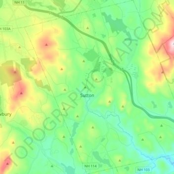
Name: Sutton topographic map, elevation, terrain.
Location: Sutton, Merrimack County, New Hampshire, United States (43.27820 -72.01426 43.40276 -71.84834)
Average elevation: 1,073 ft
Minimum elevation: 443 ft
Maximum elevation: 2,523 ft
Merrimack County trails, hiking, mountain biking, running and outdoor activities
Make a donation
Gear up for your next adventure:
As an Amazon Associate, this site earns from qualifying purchases at no extra cost to you.
Other topographic maps
Click on a map to view its topography, its elevation and its terrain.
Make a donation
Gear up for your next adventure:
As an Amazon Associate, this site earns from qualifying purchases at no extra cost to you.
Kelleys Corner
United States > New Hampshire > Merrimack County > Chichester
Average elevation: 518 ft
Make a donation
Gear up for your next adventure:
As an Amazon Associate, this site earns from qualifying purchases at no extra cost to you.
North Pembroke
United States > New Hampshire > Merrimack County > Pembroke > North Pembroke
Average elevation: 650 ft
Ragged Mountain
United States > New Hampshire > Merrimack County > Danbury
Average elevation: 1,627 ft
Newbury
United States > New Hampshire > Merrimack County > Newbury > Newbury
According to the United States Census Bureau, the town has a total area of 38.1 square miles (98.7 km2), of which 35.8 square miles (92.8 km2) are land and 2.3 square miles (5.9 km2) are water, comprising 5.94% of the town. Mount Sunapee, the highest point in town, has an elevation of 2,726 feet (831 m) above…
Average elevation: 1,496 ft
Salisbury Heights
United States > New Hampshire > Merrimack County > Salisbury > Salisbury Heights
Average elevation: 804 ft
Make a donation
Gear up for your next adventure:
As an Amazon Associate, this site earns from qualifying purchases at no extra cost to you.
