

Sutton topographic map
Click on the map to display elevation.
Sutton
Sutton is a town in Merrimack County, New Hampshire, United States. The population was 1,978 at the 2020 census. Sutton includes the villages of Sutton Mills (shown as "Sutton" on topographic maps), North Sutton, South Sutton and East Sutton. North Sutton is home to Wadleigh State Park on Kezar Lake.
About this map
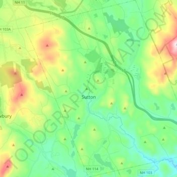
Name: Sutton topographic map, elevation, terrain.
Location: Sutton, Merrimack County, New Hampshire, United States (43.27816 -72.01426 43.40276 -71.84822)
Average elevation: 1,073 ft
Minimum elevation: 443 ft
Maximum elevation: 2,523 ft
Merrimack County trails, hiking, mountain biking, running and outdoor activities
Other topographic maps
Click on a map to view its topography, its elevation and its terrain.
Catamount Mountain
United States > New Hampshire > Merrimack County > Pittsfield
Average elevation: 922 ft


Concord Manor
United States > New Hampshire > Merrimack County > Concord > Penacook
Average elevation: 335 ft
Kezer Seminary
United States > New Hampshire > Merrimack County > Canterbury
Average elevation: 633 ft



Kezer Seminary
United States > New Hampshire > Merrimack County > Canterbury
Average elevation: 633 ft

Shaker Village
United States > New Hampshire > Merrimack County > Canterbury
Average elevation: 673 ft
Rings Corner
United States > New Hampshire > Merrimack County > Pittsfield > Rings Corner
Average elevation: 623 ft