Geolocate

Bacarra topographic map

Click on the map to display elevation.

About this map

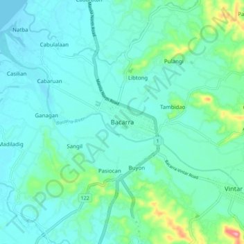
Name: Bacarra topographic map, elevation, terrain.

Location: Bacarra, Ilocos Norte, Ilocos Region, 2916, Philippines (18.21174 120.57066 18.29174 120.65066)

Average elevation: 79 ft

Minimum elevation: 0 ft

Maximum elevation: 446 ft

Other topographic maps

Click on a map to view its topography, its elevation and its terrain.

Brgy. 58- Casili

Philippines > Ilocos Norte

Average elevation: 33 ft

Pagudpud

Philippines > Ilocos Norte

The town's topography includes mountains, hills, valleys and flat coastal land.

Average elevation: 233 ft

Paoay Lake

Philippines > Ilocos Norte > Suba

Average elevation: 85 ft

Laoag

Philippines > Ilocos Norte

Average elevation: 135 ft

Gear up for your next adventure:

🪶Compact Camp Shovel - Folding shovel for campsite tasks
🧭Compass with Lanyard - Easy‑carry compass for navigation
🗺️Topographic Maps - Detailed topo maps for hiking, exploring and outdoor navigation
🔭Compact Binoculars - HD vision for scouting terrain and identifying distant landmarks
🪶Thermal Camp Blanket - Extra warmth for cold nights

As an Amazon Associate, this site earns from qualifying purchases at no extra cost to you.