
Thank you for supporting this site ❤️
Make a donation
Make a donation
Gear up for your next adventure:
As an Amazon Associate, this site earns from qualifying purchases at no extra cost to you.
McCook topographic map
Click on the map to display elevation.
Thank you for supporting this site ❤️
Make a donation
Make a donation
Gear up for your next adventure:
As an Amazon Associate, this site earns from qualifying purchases at no extra cost to you.
About this map
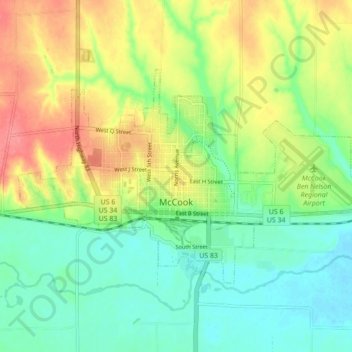
Name: McCook topographic map, elevation, terrain.
Location: McCook, Red Willow County, Nebraska, 69001, United States (40.18534 -100.66484 40.22569 -100.57789)
Average elevation: 2,549 ft
Minimum elevation: 2,454 ft
Maximum elevation: 2,690 ft
Red Willow County trails, hiking, mountain biking, running and outdoor activities
Thank you for supporting this site ❤️
Make a donation
Make a donation
Gear up for your next adventure:
As an Amazon Associate, this site earns from qualifying purchases at no extra cost to you.