
Make a donation
Gear up for your next adventure:
As an Amazon Associate, this site earns from qualifying purchases at no extra cost to you.
Nordhelle topographic map
Click on the map to display elevation.
Make a donation
Gear up for your next adventure:
As an Amazon Associate, this site earns from qualifying purchases at no extra cost to you.
About this map
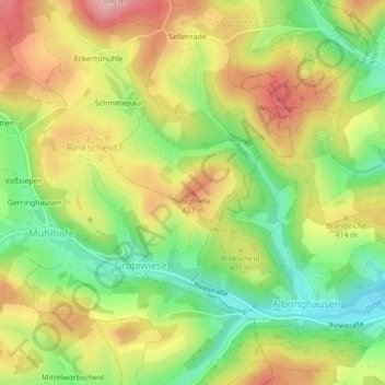
Name: Nordhelle topographic map, elevation, terrain.
Average elevation: 1,270 ft
Minimum elevation: 991 ft
Maximum elevation: 1,562 ft
Make a donation
Gear up for your next adventure:
As an Amazon Associate, this site earns from qualifying purchases at no extra cost to you.
Other topographic maps
Click on a map to view its topography, its elevation and its terrain.
Hunswinkel
Deutschland > Nordrhein-Westfalen > Märkischer Kreis > Meinerzhagen
Average elevation: 1,240 ft
Werkshagen
Deutschland > Nordrhein-Westfalen > Märkischer Kreis > Meinerzhagen
Average elevation: 1,581 ft
58540
Deutschland > Nordrhein-Westfalen > Märkischer Kreis > Meinerzhagen > Blomberg
Average elevation: 1,421 ft
Make a donation
Gear up for your next adventure:
As an Amazon Associate, this site earns from qualifying purchases at no extra cost to you.
Sundhellen
Deutschland > Nordrhein-Westfalen > Märkischer Kreis > Meinerzhagen
Average elevation: 1,316 ft
Lister
Deutschland > Nordrhein-Westfalen > Märkischer Kreis > Meinerzhagen
Die Lister verläuft innerhalb des Sauerlands im Naturpark Sauerland-Rothaargebirge. Sie entspringt innerhalb des Ebbegebirges, nördlich des Bergs Rothenstein (ca. 600 m ü. NHN). Ihre im Hochmoor Grundlose gelegene Quelle liegt im Naturschutzgebiet Auf’m Ebbe/Ebbemoore, das sich zwischen den zum…
Average elevation: 1,430 ft