
Make a donation
Gear up for your next adventure:
As an Amazon Associate, this site earns from qualifying purchases at no extra cost to you.
Hunswinkel topographic map
Click on the map to display elevation.
Make a donation
Gear up for your next adventure:
As an Amazon Associate, this site earns from qualifying purchases at no extra cost to you.
About this map
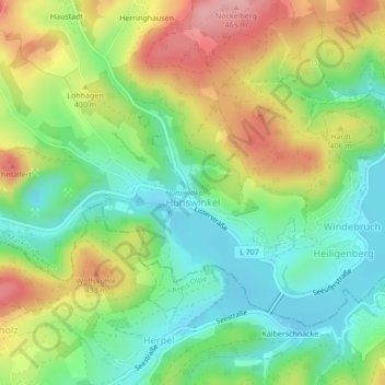
Name: Hunswinkel topographic map, elevation, terrain.
Average elevation: 1,240 ft
Minimum elevation: 1,043 ft
Maximum elevation: 1,529 ft
Make a donation
Gear up for your next adventure:
As an Amazon Associate, this site earns from qualifying purchases at no extra cost to you.
Other topographic maps
Click on a map to view its topography, its elevation and its terrain.
Roter Hahn
Deutschland > Nordrhein-Westfalen > Märkischer Kreis > Meinerzhagen > Haumche > Spädinghausen
Average elevation: 1,368 ft
Valbert
Deutschland > Nordrhein-Westfalen > Märkischer Kreis > Meinerzhagen
Durch die Lage Valberts, jahrhundertelang direkt an der Grenze zum kurkölnischen Herzogtum Westfalen, kam es des Öfteren zu Streitigkeiten, die an Brisanz noch dadurch gewannen, dass es kurkölnischen Besitz auf dem Gebiet der Mark und auch umgekehrt gab. Da diese Streitigkeiten oft auf dem Rücken der…
Average elevation: 1,555 ft
Fumberg
Deutschland > Nordrhein-Westfalen > Märkischer Kreis > Meinerzhagen
Average elevation: 1,398 ft
Werlsiepen
Deutschland > Nordrhein-Westfalen > Märkischer Kreis > Meinerzhagen
Average elevation: 1,503 ft
Make a donation
Gear up for your next adventure:
As an Amazon Associate, this site earns from qualifying purchases at no extra cost to you.
Mittelhagen
Deutschland > Nordrhein-Westfalen > Märkischer Kreis > Meinerzhagen > Vorderhagen
Average elevation: 1,565 ft
Hesselbecke
Deutschland > Nordrhein-Westfalen > Märkischer Kreis > Meinerzhagen > Nordhellen
Average elevation: 1,568 ft
Höh
Deutschland > Nordrhein-Westfalen > Märkischer Kreis > Meinerzhagen > Valbert
Average elevation: 1,483 ft
Make a donation
Gear up for your next adventure:
As an Amazon Associate, this site earns from qualifying purchases at no extra cost to you.
Nordhelle
Deutschland > Nordrhein-Westfalen > Märkischer Kreis > Meinerzhagen
Average elevation: 1,270 ft
Lengelscheid
Deutschland > Nordrhein-Westfalen > Märkischer Kreis > Meinerzhagen
Average elevation: 1,594 ft
58540
Deutschland > Nordrhein-Westfalen > Märkischer Kreis > Meinerzhagen > Blomberg
Average elevation: 1,421 ft
Rinkscheid
Deutschland > Nordrhein-Westfalen > Märkischer Kreis > Meinerzhagen
Average elevation: 1,335 ft
Make a donation
Gear up for your next adventure:
As an Amazon Associate, this site earns from qualifying purchases at no extra cost to you.
Lister
Deutschland > Nordrhein-Westfalen > Märkischer Kreis > Meinerzhagen
Die Lister verläuft innerhalb des Sauerlands im Naturpark Sauerland-Rothaargebirge. Sie entspringt innerhalb des Ebbegebirges, nördlich des Bergs Rothenstein (ca. 600 m ü. NHN). Ihre im Hochmoor Grundlose gelegene Quelle liegt im Naturschutzgebiet Auf’m Ebbe/Ebbemoore, das sich zwischen den zum…
Average elevation: 1,430 ft
Krummenerl
Deutschland > Nordrhein-Westfalen > Märkischer Kreis > Meinerzhagen
Average elevation: 1,348 ft
Unterworbscheid
Deutschland > Nordrhein-Westfalen > Märkischer Kreis > Meinerzhagen > Grotewiese
Average elevation: 1,253 ft
Hösinghausen
Deutschland > Nordrhein-Westfalen > Märkischer Kreis > Meinerzhagen > Valbert
Average elevation: 1,545 ft
Make a donation
Gear up for your next adventure:
As an Amazon Associate, this site earns from qualifying purchases at no extra cost to you.
Heiligenberg
Deutschland > Nordrhein-Westfalen > Märkischer Kreis > Meinerzhagen > Heiligenberg
Average elevation: 1,220 ft
Nordhellen
Deutschland > Nordrhein-Westfalen > Märkischer Kreis > Meinerzhagen
Average elevation: 1,526 ft
Hülseberg
Deutschland > Nordrhein-Westfalen > Märkischer Kreis > Meinerzhagen
Average elevation: 1,621 ft
Oberworbscheid
Deutschland > Nordrhein-Westfalen > Märkischer Kreis > Meinerzhagen > Mühlhofe
Average elevation: 1,296 ft
Make a donation
Gear up for your next adventure:
As an Amazon Associate, this site earns from qualifying purchases at no extra cost to you.
Hardenberg
Deutschland > Nordrhein-Westfalen > Märkischer Kreis > Meinerzhagen
Average elevation: 1,437 ft
Wiebche
Deutschland > Nordrhein-Westfalen > Märkischer Kreis > Meinerzhagen > Eseloh
Average elevation: 1,329 ft
Scherl
Deutschland > Nordrhein-Westfalen > Märkischer Kreis > Meinerzhagen
Average elevation: 1,519 ft
Hohenhengstenberg
Deutschland > Nordrhein-Westfalen > Märkischer Kreis > Meinerzhagen > Nordhellen
Average elevation: 1,601 ft
Make a donation
Gear up for your next adventure:
As an Amazon Associate, this site earns from qualifying purchases at no extra cost to you.
Mettgenberg
Deutschland > Nordrhein-Westfalen > Märkischer Kreis > Meinerzhagen
Average elevation: 1,640 ft