Geolocate

Underhill topographic map

Interactive map

Click on the map to display elevation.

About this map

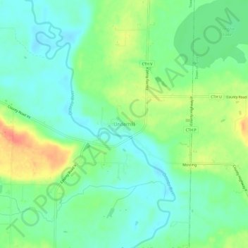
Name: Underhill topographic map, elevation, terrain.

Location: Underhill, Town of Underhill, Oconto County, Wisconsin, 54124, United States (44.85527 -88.40455 44.89527 -88.36455)

Average elevation: 817 ft

Minimum elevation: 761 ft

Maximum elevation: 919 ft

Routes: Oconto County GPS tracks, routes, trails, hikes

Other topographic maps

Click on a map to view its topography, its elevation and its terrain.

Town of Oconto

United States > Wisconsin > Oconto County

Average elevation: 633 ft

Suring

United States > Wisconsin > Oconto County

Average elevation: 814 ft

Lakewood

United States > Wisconsin > Oconto County

Average elevation: 1,286 ft

Lena

United States > Wisconsin > Oconto County

Average elevation: 702 ft

Town of Mountain

United States > Wisconsin > Oconto County

Average elevation: 994 ft

Town of Riverview

United States > Wisconsin > Oconto County

Average elevation: 1,073 ft

Trout Lake

United States > Wisconsin > Oconto County

Average elevation: 1,289 ft

Maiden Lake

United States > Wisconsin > Oconto County

Average elevation: 1,227 ft

Townsend

United States > Wisconsin > Oconto County > Townsend

Average elevation: 1,345 ft

Gillett

United States > Wisconsin > Oconto County

Average elevation: 830 ft