Geolocate

Central topographic map

Click on the map to display elevation.

About this map

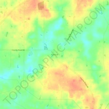
Name: Central topographic map, elevation, terrain.

Location: Central, Jackson County, Alabama, 35765, United States (34.64619 -85.81053 34.68619 -85.77053)

Average elevation: 1,394 ft

Minimum elevation: 1,319 ft

Maximum elevation: 1,460 ft

Jackson County trails, hiking, mountain biking, running and outdoor activities

Other topographic maps

Click on a map to view its topography, its elevation and its terrain.

Langston

United States > Alabama > Jackson County

Average elevation: 797 ft

Paint Rock

United States > Alabama > Jackson County

Average elevation: 810 ft

Pleasant Groves

United States > Alabama > Jackson County

Average elevation: 1,086 ft

Skyline

United States > Alabama > Jackson County

Average elevation: 1,276 ft

Hytop

United States > Alabama > Jackson County

Average elevation: 1,355 ft

Dutton

United States > Alabama > Jackson County

Average elevation: 1,345 ft

Scottsboro

United States > Alabama > Jackson County

Average elevation: 771 ft

Stevenson

United States > Alabama > Jackson County

Average elevation: 810 ft

Paint Rock

United States > Alabama > Jackson County

Average elevation: 817 ft

Pisgah

United States > Alabama > Jackson County > Pisgah

Average elevation: 1,375 ft

Gear up for your next adventure:

🚪Portable Camp Chair - Foldable chair for comfort at camp
🧺Microfiber Travel Towels - Compact and fast-drying towels for trail use
🔭Stargazing Telescopes - Perfect for camping in low-light pollution areas shown on maps
🔌Solar Panel Charger - Charge gear sustainably outdoors
🍳Camping Cook Set - Complete cookware for outdoor meals

As an Amazon Associate, this site earns from qualifying purchases at no extra cost to you.