Geolocate

Koa topographic map

Click on the map to display elevation.

About this map

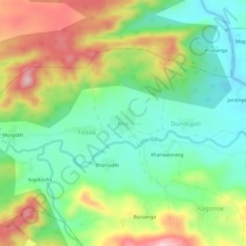
Name: Koa topographic map, elevation, terrain.

Location: Koa, Erki(Tamar II), Khunti, Jharkhand, India (22.92883 85.37597 22.96883 85.41597)

Average elevation: 1,614 ft

Minimum elevation: 1,302 ft

Maximum elevation: 2,106 ft

Other topographic maps

Click on a map to view its topography, its elevation and its terrain.

Taiba

India > Jharkhand > Erki(Tamar II)

Average elevation: 1,850 ft

Gear up for your next adventure:

🪶Camp Gear Gift Set - Perfect gift bundle for outdoor fans
🔦LED Headlamp - Bright and durable LED headlamp for night navigation
🥾Hiking Shoes - Durable and comfortable shoes for trail hiking
😴Insulated Sleeping Pads - Compact and warm pads for high-elevation camping
📡GPS Antenna Upgrade - Enhance GPS reception in remote terrain

As an Amazon Associate, this site earns from qualifying purchases at no extra cost to you.