Geolocate

Kiminini topographic map

Click on the map to display elevation.

About this map

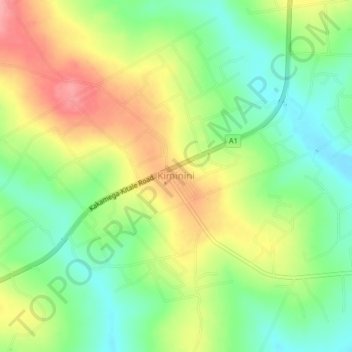
Name: Kiminini topographic map, elevation, terrain.

Location: Kiminini, Trans-Nzoia County, Kenya (0.87259 34.90515 0.91259 34.94515)

Average elevation: 5,755 ft

Minimum elevation: 5,614 ft

Maximum elevation: 5,932 ft

Gear up for your next adventure:

🧴Hand Sanitizer - Keep hands clean while hiking
📚USA Hiking Guide Books - Top trail guides and map books
🏫Relief Map Kits - Hands-on tools for teaching landforms and elevation
🔋Solar Power Banks - Keep your GPS and phone charged in remote wilderness areas
🛡️Bear Spray Outdoor - Protection in bear country hikes

As an Amazon Associate, this site earns from qualifying purchases at no extra cost to you.