
Make a donation
Gear up for your next adventure:
As an Amazon Associate, this site earns from qualifying purchases at no extra cost to you.
Forallac topographic map
Click on the map to display elevation.
Make a donation
Gear up for your next adventure:
As an Amazon Associate, this site earns from qualifying purchases at no extra cost to you.
About this map
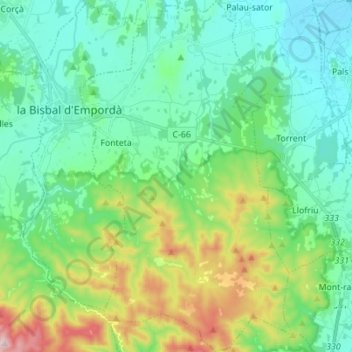
Name: Forallac topographic map, elevation, terrain.
Location: Forallac, Bas-Ampurdan, Gérone, Catalogne, Espagne (41.88893 3.04365 41.99174 3.12726)
Average elevation: 351 ft
Minimum elevation: 0 ft
Maximum elevation: 1,391 ft
Make a donation
Gear up for your next adventure:
As an Amazon Associate, this site earns from qualifying purchases at no extra cost to you.
Other topographic maps
Click on a map to view its topography, its elevation and its terrain.
Platja d'Aro
Espagne > Catalogne > Bas-Ampurdan > Castell d'Aro, Platja d'Aro i s'Agaró
Average elevation: 154 ft
Castell d'Aro
Espagne > Catalogne > Bas-Ampurdan > Castell d'Aro, Platja d'Aro i s'Agaró
Average elevation: 308 ft
Make a donation
Gear up for your next adventure:
As an Amazon Associate, this site earns from qualifying purchases at no extra cost to you.
Make a donation
Gear up for your next adventure:
As an Amazon Associate, this site earns from qualifying purchases at no extra cost to you.