
Make a donation
Gear up for your next adventure:
As an Amazon Associate, this site earns from qualifying purchases at no extra cost to you.
Kampung Kasipillay topographic map
Click on the map to display elevation.
Make a donation
Gear up for your next adventure:
As an Amazon Associate, this site earns from qualifying purchases at no extra cost to you.
About this map
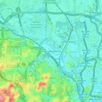
Name: Kampung Kasipillay topographic map, elevation, terrain.
Location: Kampung Kasipillay, Kuala Lumpur, 51000, Malaysia (3.15709 101.66161 3.19709 101.70161)
Average elevation: 177 ft
Minimum elevation: 89 ft
Maximum elevation: 449 ft
Make a donation
Gear up for your next adventure:
As an Amazon Associate, this site earns from qualifying purchases at no extra cost to you.
Other topographic maps
Click on a map to view its topography, its elevation and its terrain.
Proposed Royal Garden Sri Putramas 4
Malaysia > Kuala Lumpur > Kampung Kasipillay
Average elevation: 174 ft
Make a donation
Gear up for your next adventure:
As an Amazon Associate, this site earns from qualifying purchases at no extra cost to you.