Geolocate

Brickfields topographic map

Click on the map to display elevation.

About this map

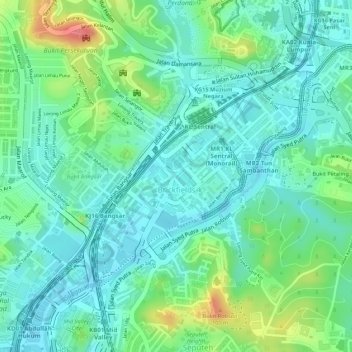
Name: Brickfields topographic map, elevation, terrain.

Location: Brickfields, Kuala Lumpur, 50470, Malaysia (3.12185 101.67844 3.13794 101.69460)

Average elevation: 161 ft

Minimum elevation: 79 ft

Maximum elevation: 354 ft

Other topographic maps

Click on a map to view its topography, its elevation and its terrain.

Perdana Botanical Gardens

Malaysia > Kuala Lumpur

Average elevation: 177 ft

Kampung Kasipillay

Malaysia > Kuala Lumpur

Average elevation: 177 ft

Kampung Hujung Pasir

Malaysia > Kuala Lumpur

Average elevation: 151 ft

Titiwangsa Lake Park

Malaysia > Kuala Lumpur

Average elevation: 141 ft

Duta Nusantara Park

Malaysia > Kuala Lumpur

Average elevation: 269 ft

Gear up for your next adventure:

🥤Water Filter Bottle - All‑in‑one filter bottle for safe hydration
🪶Camp Gear Gift Set - Perfect gift bundle for outdoor fans
Camping Coffee Makers - Enjoy premium coffee at the summit or campsite
🔦Powerful Headlamps - Ultra-bright hands-free lighting for night navigation
🧦Hiking Socks - Comfortable socks to prevent blisters on long hikes

As an Amazon Associate, this site earns from qualifying purchases at no extra cost to you.